Collapse & conflict
How to Build a Local Emergency Map Before Your Phone Goes Offline
You probably know the fastest way to the grocery store. Could you find a different way out of your neighborhood if the usual bridge closed and your phone cou...
Quick answer
Print a readable neighborhood map and regional road map, mark meeting places and realistic destinations, and note routes with different bottlenecks. Add a private contact sheet and locally verified radio information. Download and test offline maps, but follow current local instructions about evacuation or sheltering rather than treating any planned route as guaranteed.
You probably know the fastest way to the grocery store. Could you find a different way out of your neighborhood if the usual bridge closed and your phone could not load a map?
Build a small map packet before you need it: a readable neighborhood map, a regional road map, and a private household information sheet. Add an offline map to your phone as a backup. The goal is not to predict every closure. It is to stop depending on one screen and one familiar route.
Start with local plans, not guessed escape routes
In the United States, check your city or county emergency management website and your state's evacuation guidance. Look for evacuation zones, designated routes, local hazards, and transportation assistance. Elsewhere, start with the equivalent local authority. This map supports your local emergency plan, not evacuation during every emergency. Follow local instructions about whether to evacuate or shelter in place.
Ready.gov's evacuation guidance recommends knowing local plans, identifying destinations in different directions, and familiarizing yourself with alternate routes and transportation options.
Write down where you will get official updates. A printed map shows geography, not current conditions. During an incident, follow local officials and recommended evacuation routes. Do not take an improvised shortcut around a closure, and never drive into floodwater.
Make two maps you can actually read
Start with maps from local government websites or a street map you can print clearly. An inexpensive regional road map is another option. Use two views rather than shrinking everything onto one crowded page:
Neighborhood map: Your home area, nearby streets, exits from the neighborhood, and household meeting places.
Regional map: Main roads, surrounding towns, official evacuation routes where provided, and plausible destinations beyond your immediate area.
Check the printed copy, not just the screen. Street names should be legible. Keep the north indicator, scale, and map legend visible, or add a simple legend for your own markings. Avoid covering road labels with thick marker lines.
Label the area and note when you prepared the packet. Keep it in a protective sleeve or resealable bag, somewhere your household can find it quickly. A second copy in your evacuation bag is useful if leaving home is part of your plan.
Mark destinations before drawing routes
Mark a nearby meeting place for a household separation, such as a familiar public location that is safe and accessible under normal conditions. Also identify places farther away in different directions, such as relatives or friends who have agreed you could come.
A building used during a previous disaster is not necessarily an open shelter today. Mark a site as a potential shelter only where local authorities identify it, and confirm which shelters are open and whether they can accommodate your household's accessibility and pet needs through current official information.
You can also mark hospitals, pharmacies, fuel stations, and public facilities you may need. Treat these as locations, not promises: power outages or the emergency itself may affect access, opening hours, fuel, and services.
Do not label a lake, stream, or public building as a guaranteed water supply. A map does not establish that water is potable, that a tap works, or that you have permission to enter.
Look for different bottlenecks, not different-colored lines
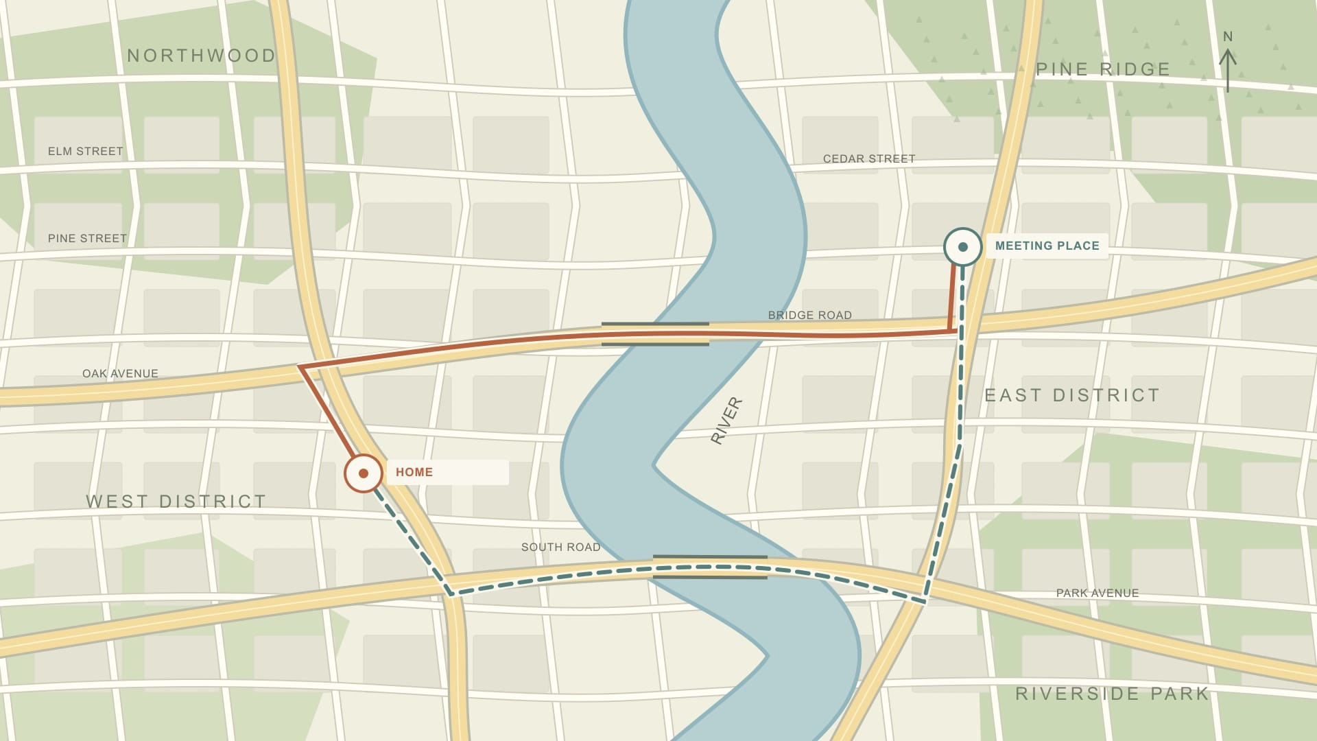
Draw a normal route and a planning alternative to each important destination. Then look at what the routes share.
Two roads that merge before the same bridge do not provide independent options if that bridge is unavailable. The same applies to routes that depend on one underpass, highway entrance, or narrow exit from your neighborhood.
Note those shared bottlenecks on the map. Where legal public routes exist, look for an option that uses a different crossing or leaves in another direction. This is preparation, not permission to ignore incident-specific routing.
For a broader departure plan, our guide to leaving a city after a disaster covers decisions beyond the map itself.
If you do not drive, build the plan around realistic transportation. Record official evacuation transport arrangements where available, who can help, and where pickup would occur. Routine transit service is not a guarantee during an emergency.
For walking or wheelchair travel, consider sidewalks, crossings, slopes, and accessibility. Do not substitute railway tracks, private property, or unfamiliar off-road shortcuts for a usable public route.
Add a private information sheet and radio details
Keep essential household details on a separate sheet rather than crowding the map. Include:
Household and out-of-area contact numbers.
Meeting-place names and full addresses.
Destination contacts and agreed arrangements.
Local emergency information numbers and official information sources.
Essential medical, accessibility, language, and pet-related needs.
Ready.gov's household planning guidance emphasizes making plans around the people in your household and practicing them. Discuss who needs help, who collects children, and what happens if family members cannot communicate.
Keep sensitive details private. Do not put door codes, hidden-key locations, or unnecessary medical information on a map you might hand to someone else. Share the relevant plan with trusted household members.
Use local emergency management guidance to identify radio stations carrying official instructions. Record station names and frequencies, then test reception with your battery-powered radio where you expect to use it. Do not assume one station reaches every destination or that reception is reliable indoors.
For additional communication backups, see what to do when cell service goes down.
Download offline maps, but know their limits
Paper and offline maps solve different problems. Paper needs no battery. Download an area that contains the entire planned route and its destination. Google says a route must fall within the downloaded map for offline navigation to work.
According to Google Maps' offline-map documentation, offline walking, cycling, and public transit directions are unavailable. Offline driving does not provide traffic information or alternate routes. Downloads are also unavailable in some countries or regions, and maps need updating before they expire.
Test the actual app and downloaded area before relying on them. With mobile data and Wi-Fi switched off, check whether the saved map opens and whether a planned driving route works. Keep your paper copy even after a successful test.
Practice once, then update when something changes
On an ordinary day, ask a household member to use the paper map to find a meeting place and describe a route. If you walk or drive it, follow normal road rules. A driver should pull over safely before studying the map, or let a passenger navigate.
Check only safe, public routes. Do not enter restricted areas or approach hazardous infrastructure to investigate your plan.
Review the packet when you move, roads change, destinations change, household needs change, or local authorities revise evacuation guidance. Refresh offline downloads before they expire.
Before putting the packet away, check that you have:
Readable neighborhood and regional maps.
Realistic destinations and clearly labeled meeting places.
Route options with shared bottlenecks noted.
Private contact and household information.
Official update sources and tested radio reception.
An offline map that covers the routes you intend to use.
Editorial note
This guide uses U.S. preparedness guidance and Google Maps documentation. Local evacuation instructions, closures, and shelter announcements take priority over a preplanned map. Outside the United States, use your local emergency authority's guidance.
Article recap
- Pair paper maps with tested offline maps so navigation does not depend on a working internet connection or a charged phone.
- Choose realistic destinations and routes with different bottlenecks. A marked shelter, fuel station, or water source is not guaranteed usable.
- Keep contacts private, practice in normal conditions, and update the packet when roads, household needs, or official plans change.
Sources and further reading
- Ready.gov: Evacuation — accessed Aug 2026
- Ready.gov: Make a Plan — Ready.gov, accessed May 2026
- Google Maps Help: Download areas and navigate offline — Google Maps Help, accessed Oct 2026
Read next
Questions readers askFrequently asked questions
Yes, with limitations. Download the area beforehand, with the entire route inside it. Offline Google Maps does not provide walking, cycling, or transit directions, and offline driving lacks traffic information and alternate routes. Test your saved map and keep a paper backup.
Mark household meeting places, agreed destinations, relevant public roads, official evacuation routes where provided, and shared bottlenecks. Add useful facilities cautiously: a mapped location does not mean it is open, accessible, or supplying services during an emergency.
Not automatically. Your alternatives are planning aids, not incident instructions. Follow local officials and recommended evacuation routes. Do not bypass closures with improvised shortcuts or drive into floodwater.
Comments
Leave a comment
No comments yet. Be the first to comment!